
-
- My Homes
- My Tours
- My Favorites
- My Searches
- Sign In
- Register
Flying High: How Aerial Cars Can Revolutionize Land Viewing
by FD Bell
Introduction
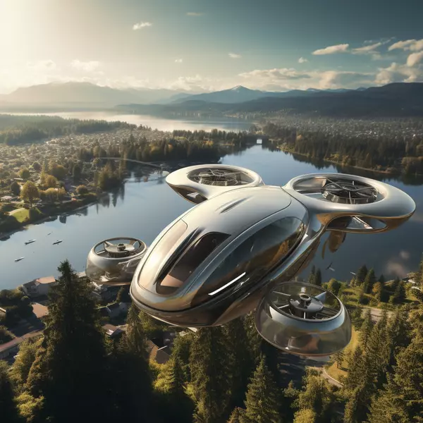
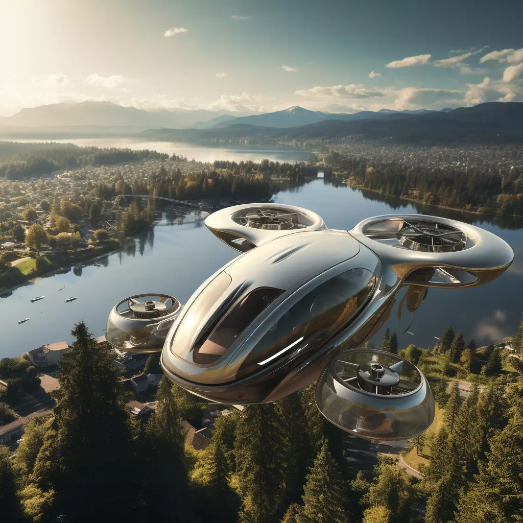
Imagine cruising through the skies in your very own flying car, effortlessly surveying a potential piece of land from a bird's-eye view. No longer confined to the roads, you can now glide above creeks, dense timber, internal roads, and winding trails, all from the comfort of your aerial car. The concept sounds like something straight out of a science fiction novel, doesn't it?
Yet, with recent technological advancements in aerial transportation, this futuristic vision is edging closer to reality. Whether you're a land developer, real estate agent, or simply someone interested in buying property, the ability to view land parcels from above could transform the way you evaluate and manage land. Intrigued? Let's dive into the progress being made towards making flying cars a reality and explore how this could revolutionize the way you view potential land parcels.
The Progress Towards Flying Aerial Cars
In recent years, flying cars have moved from the pages of science fiction to the drawing boards of engineers and the labs of innovators. Companies like Terrafugia, PAL-V, and AeroMobil are at the forefront, each developing unique prototypes that combine the functionality of traditional vehicles with the freedom of flight.
From vertical takeoff and landing (VTOL) capabilities to hybrid electric propulsion systems, technology is rapidly evolving. These advancements are not just about making vehicles that can fly, but making them safe, efficient, and accessible. Regulatory bodies are also getting involved, laying down the groundwork for air traffic management systems that can handle a new dimension of travel.
Viewing Potential Land Parcels from Aerial Cars
Imagine this: you're considering a piece of property but unsure of its true potential. Instead of walking the land or relying on outdated maps, you hop into your aerial car. Within minutes, you're soaring above the property, taking in every detail. You can easily spot natural features like creeks and dense timber, assess the condition of internal roads and trails, and even identify potential problem areas.
The bird's-eye view provides a more comprehensive understanding of the land's layout and features. It makes the evaluation process faster and more accurate, allowing you to make informed decisions without setting foot on the ground.
Advantages of Viewing Land Parcels from Aerial Cars
Using an aerial car to view land parcels offers several significant advantages:
-
Enhanced Perspective: Get a complete view of the property, including areas that are hard to access on foot.
-
Time Efficiency: Quickly survey large areas without the need for multiple site visits.
-
Cost Savings: Reduce the need for hiring surveyors, drones, or other expensive equipment.
-
Environmental Awareness: Identify environmentally sensitive areas like wetlands or wildlife habitats more easily.
-
Decision-Making: Make better-informed decisions by having a full picture of the land's topography and features.
Challenges to Overcome
While the idea of surveying land from an aerial car is thrilling, several challenges need addressing:
-
Regulations: Airspace laws and regulations need to evolve to accommodate flying cars.
-
Safety: Ensuring the reliability and safety of these vehicles is crucial.
-
Cost: Initial costs may be high, making it less accessible for some.
-
Infrastructure: Developing the necessary infrastructure for takeoff, landing, and maintenance.
-
Public Acceptance: Gaining public trust and acceptance is vital for widespread adoption.
Future Implications
The implications of integrating aerial cars into land evaluation processes are profound. Imagine a world where land transactions are quicker, more transparent, and environmentally conscious. Developers could plan more efficiently, and buyers could gain a true understanding of their investment without stepping out of their homes. The real estate industry could see a significant transformation, driven by technology that was once considered futuristic.
Conclusion
The dream of flying cars is no longer a distant fantasy. With rapid technological advancements and growing interest in aerial transportation, the ability to view land parcels from the sky is becoming increasingly feasible. From enhancing perspectives to saving time and costs, the benefits are undeniable. However, challenges remain, and overcoming them will require collaboration, innovation, and adaptation.
Imagine a future where you can evaluate a piece of land in minutes from the comfort of your aerial car. It's a thrilling possibility that could revolutionize how we see and interact with the world around us. As we edge closer to this new era, the sky is truly the limit.
Introduction
Imagine cruising through the skies in your very own flying car, effortlessly surveying a potential piece of land from a bird's-eye view. No longer confined to the roads, you can now glide above creeks, dense timber, internal roads, and winding trails, all from the comfort of your aerial car. The concept sounds like something straight out of a science fiction novel, doesn't it?
Yet, with recent technological advancements in aerial transportation, this futuristic vision is edging closer to reality. Whether you're a land developer, real estate agent, or simply someone interested in buying property, the ability to view land parcels from above could transform the way you evaluate and manage land. Intrigued? Let's dive into the progress being made towards making flying cars a reality and explore how this could revolutionize the way you view potential land parcels.
The Progress Towards Flying Aerial Cars
Flying cars have long been a symbol of the future. Recent progress in technology has made them more than just a figment of our imaginations. Companies like Aeromobil, Terrafugia, and Uber are at the forefront of this innovation, working tirelessly to bring flying cars from concept to reality.
These companies are developing vehicles that combine the best features of cars and airplanes. Think vertical takeoff and landing (VTOL) capabilities, hybrid engines, and smart navigation systems. They’re not just cool to look at; they’re designed to be practical and user-friendly. Researchers are making strides in battery technology, aerodynamics, and automated flight controls, making these vehicles safer and more efficient.
Viewing Potential Land Parcels from Aerial Cars
Now, imagine how this technology could change the way you view potential land parcels. Instead of trudging through rough terrain or guessing what's beyond that thick grove of trees, you can simply fly over the area. From above, you’ll get a clear view of creeks, timber stands, internal roads, and trails.
This aerial perspective provides a comprehensive understanding of the land's layout. It’s like having a live, interactive map at your disposal. You can see where water sources are located, how the land is divided, and even identify potential problem areas like erosion or flooding zones. This level of detail is invaluable for making informed decisions.
Advantages of Viewing Land Parcels from Aerial Cars
The benefits of this new approach are numerous:
-
Efficiency: Cover more ground in less time.
-
Comprehensive Views: See the entire property at once, rather than piecing together sections.
-
Accessibility: Reach areas that are hard to get to on foot or by traditional vehicles.
-
Safety: Avoid physical hazards like difficult terrain or wildlife.
-
Environmental Insight: Better understand the ecosystem and natural features of the land.
These advantages make the process not only quicker but also more thorough and enjoyable.
Challenges to Overcome
Of course, there are challenges to making flying cars a mainstream reality. Regulatory hurdles are significant. Airspace is tightly controlled, and integrating flying cars will require new rules and systems. Additionally, the cost of developing and producing these vehicles is high, potentially making them expensive for consumers initially.
Moreover, there are technical challenges, such as ensuring battery life and safety protocols. Infrastructure, like landing pads and charging stations, will need to be developed. But with the current pace of innovation, these challenges are not insurmountable.
Future Implications
The implications of this technology go beyond just land viewing. Imagine urban landscapes with flying cars reducing traffic congestion, or emergency services using them for rapid response. The possibilities are endless and exciting. For now, focusing on land viewing offers a promising and practical application that could revolutionize the real estate and land development industries.
Conclusion
Flying cars are on the horizon, bringing with them a host of new possibilities. For those in the market for land, the ability to view potential parcels from the sky offers unparalleled advantages. While there are challenges to overcome, the benefits make it worth the effort. As technology continues to advance, the dream of soaring above the earth in your very own aerial car is closer than ever to becoming a reality.
FAQ
Q: What companies are leading the development of flying cars?
A: Companies like Aeromobil, Terrafugia, and Uber are at the forefront of flying car innovation.
Q: What are the main advantages of viewing land parcels from an aerial car?
A: Efficiency, comprehensive views, accessibility, safety, and better environmental insight.
Q: What challenges need to be overcome for flying cars to become mainstream?
A: Regulatory hurdles, high costs, technical challenges, and the need for new infrastructure.
Q: How could flying cars impact industries beyond real estate?
A: They could reduce urban traffic congestion and enhance emergency response times, among other possibilities.
**Q: Is the concept of flying cars purely futuristic, or is it becoming a reality
Recent Posts